|
Home - The Village Today - History - Maps - Memories - Newspapers - Picture Gallery - World Wars |
|
Home - The Village Today - History - Maps - Memories - Newspapers - Picture Gallery - World Wars |
|
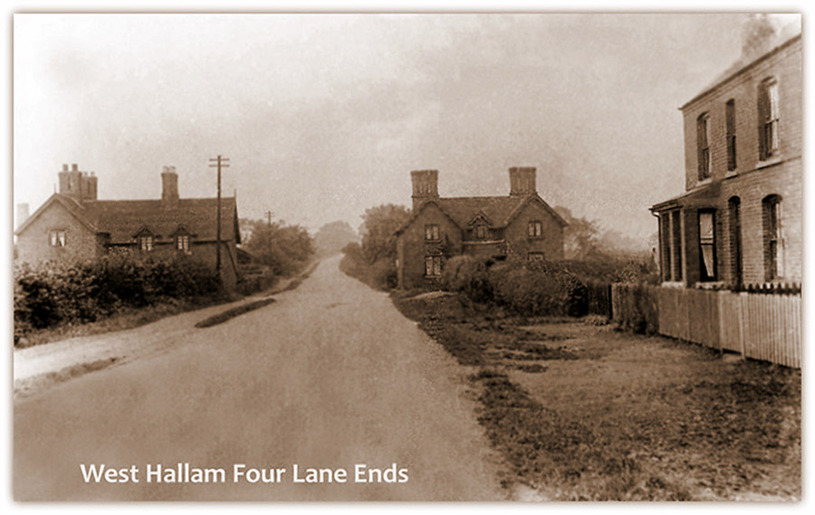
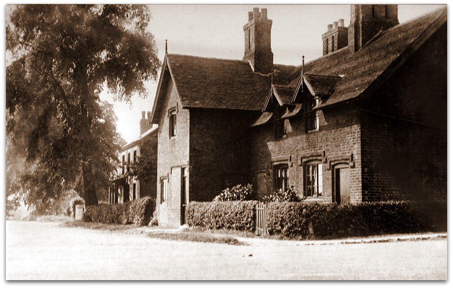
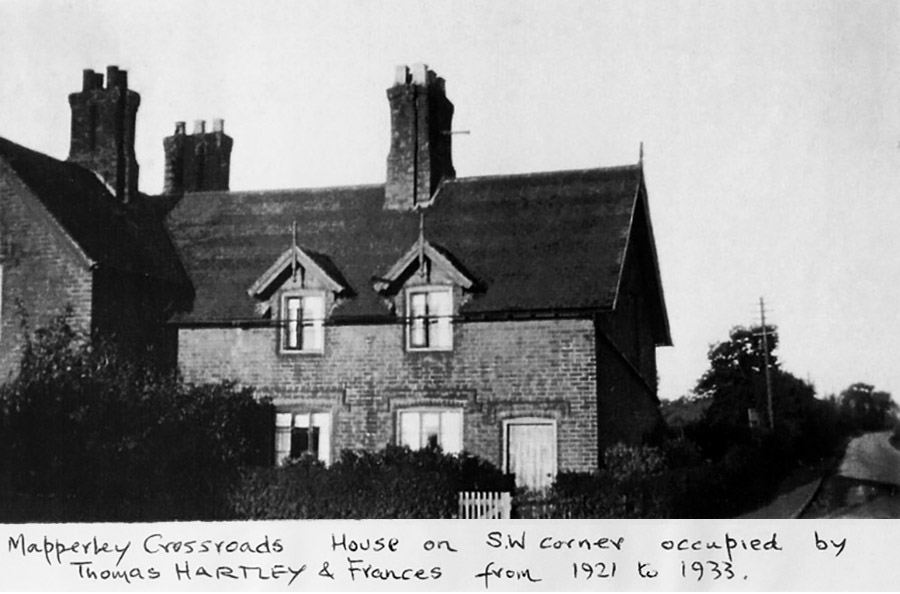
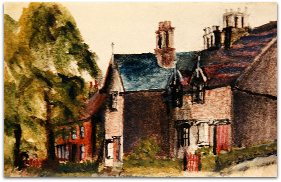
West Hallam Assorted Photographs The History of the High Lane Central Area Written by Kirsty Annable as a Scargill School Project C 2004 High Lane Central as a roadway has been here for a long time. It is split into three parts, West, East and Central. Its importance as a road can be seen from the time when a trust was set up between Bramcote, Smalley and Ilkeston in 1764, when it became a toll road. The road became a ‘free’ road again in 1863. Today High Lane is a busy main road, that runs from Ilkeston to Stanley Common. On High Lane Central there are 60 houses - 21 bungalows, 16 detached houses, 22 semi-detached houses and a children’s day nursery. I have lived at 151 High Lane Central for 8 years. Our house is a semi - detached house and was built in the 1930’s, when it was built it cost £500. It was built by Mr D Bladon. My next-door neighbour Mr D Williams, has lived in his house since it was built and it cost him £510. Mr Williams has seen a lot of changes over his lifetime. He remembers when he used to deliver paraffin with his dad around West Haliam with a horse and cart. The horse was called Nobby. Next door to Mr D William’s lives Mr and Mrs D Gillman, their house used to be a chip shop which was owned by Mr and Mrs Wilkinson. You can still see the old chip shop doorway on the side of the house if you know where to look, lire chip shop shut in 1938 when the Wilkinson’s opened a general store on the comer of the Pit Lane and High Lane Central. The store changed hands many times and it closed in 1993. Now it is a children’s day nursery. On the opposite side of Pit Lane to the nursery, there is The Newdigate Arms, which was built by Richard Slaney. He also built the white houses below the Newdigate Arms, this area used to be known as ‘White City’. Richard Slaney was West Hallam’s first fatal car accident victim in 1925, he was killed as he walked near The Newdigate Arms. Richard Slaney’s grandson, Sir Geoffrey Slaney, helped to invent hole in the heart surgery and he used to live on Lewcote Lane, West Hallam. Before the Newdigate Arms was built, the pub was at Arbury Farm. It was named after the Newdigate family home at Arbury, Warwickshire. At the bottom of Pit Lane there was a coal mine, it was one of the largest mines in West Hallam. Coal has been mined in this area since the 1600’s. There were tramways made for taking coal to the Nutbrook Canal and the coal was taken away by boat. This coalmine provided work for the local men until 1931. The site was used after the pit closed for sorting coal and there was a coal weighbridge on High Lane Central opposite numbers 143 and 145 when opencast mining came to West Hallam in 1942. The Nutbrook Canal was built in (1793-96), to carry coal to Leicester and London from the collieries of Shipley and West Hallam. Tolls were first taken in November 1794 on this section of the canal. The toll to pay was 9d (4p) per ton. The canal had 13 locks and you can still see some of them today. The canal closed in 1895, after the Great Northern Railway Company opened its railway though West Hallam in 1878. The railway track ran beside the canal. There were three petrol stations in West Hallam, one was on High Lane Central. It was called Four Winds and opened in the 1950’s and closed in 1970. It was built for the Harpur family. Houses have now been built on the site, one of which is lived in by my Aunt and Uncle, Mr and Mrs Glenn Johnson. There is a small children’s playground on High Lane Central and it is here that a circus visited in 1950. In the field next to Lewcote Gate Farm there used to be an osier bed. An osier is a water willow tree used for basket making. The willow trees surrounded the pond and there was lots of wildlife. Today the pond is smaller and a few willow trees are left, as the land has settled because of coal mining in the neighbouring fields. My thanks to Kirsty and to Maureen West for being kind enough to make me aware of the work. Maureen's father, Dennis Williams, assisted Kirsty with some facts at the time. Mapperley Crossroads Mapperley Crossroads as we know it today was constructed in 1823 when Lord of the Manor, Francis Newdigate had recently bought the West Hallam estate, which he purchased from the Hunlokes. He had his property surveyed and the crossroads had only then recently been created by the removal of both the old Mapperley Sick Lane and Hurton Lane. On completion it was known as “Four Lane Ends”. The main road, called the High Lane, was a continuous road from the Nutbrook Boundary (West Hallam/Ilkeston), Straws Bridge, leading to the West Hallam Common Lane. (Mill Garage Crossroads). It is now split into East, Central and West. The lane leading to Mapperley village was named “Mapperley Sick Lane”. On the opposite side, the lane leading to West Hallam village was named “Hurton’s Lane”. Now named St. Wilfrid’s Road. Coppice Farm on Mapperley Lane is angled from the road due to the road layout being changed on creating the crossroads. Roger Wood 2018 The cottage to the centre-left on Mapperley Lane was removed in the 1920s-30s to enable road widening.
You see this if you drive from Mapperley to the crossroads with High Lane West and High Lane Central. It is the corner of St Wilfred's Road and High Lane West. The nearest house was the home of the Hart sometimes called Hartshorne family. The daughter Doris had the house pulled down and a bungalow built in its place when her parents died some years ago. The second house next to it was where the milkman Maurice Stevens lived. (The photograph was owned by Frank Hartshorne who recently passed away. His daughter Carole Hartshorne very kindly donated it to us. The information about this photograph was supplied by Brenda Parker, who remains a great source of information) April 2017
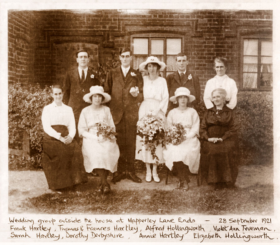
New information 2022. The property was actually built as four small cottages, later converted to two larger cottages. My grandparents Thomas and Frances Hartley (Thomas being the grandson of Thomas and Ann Hartley of Orchard Farm) moved into the right hand side, nearest High Lane, after their wedding in 1921. My father Jack (John) was born there in April 1925. I am not certain of these next details or the date but my father told me that their side of the Four Lane Ends cottage was demolished as part of a road widening / straightening scheme some time after they had moved. I don't know how long after they had left or even if anybody else lived there after them and before its demolition. Gillian Bosworth If anyone has any further information or photographs I would love to hear from you.
Disclaimer - Copyright - Is this page correct? Something wrong or missing? Please let me know. Also contributions very welcome |